Traffic Navigation
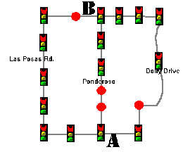
Above: The streets of Camarillo, California. Red dots are stop signs and the other graphic represents stoplights.
Purpose: Driving the car is an American time honored tradition. In theory the quickest point between two points is a straightline, however, with the advent of stop lights and stop signs, driving has been transformed into a virtual art form where the quickest way tends to be not A to B, but A to C to D to E then to B. This experiment will test three different routes to see which is fastest in getting from one side of town to the other.
Hypothesis: The hypothesis of this experiment is that the straightline will not be the fastest. The fastest route will be the route with the least stop signs and stop lights on average. Therefore, the route on the right side, the Daily Drive route will be the fastest.
Equipment: Required for this experiment is a ordinary city with terrible traffic conditions, a car with working odometer (Milage Thingy), a stopwatch, Pen and Paper, and calculator optional.
Procedure: The first step is to analyze the city, and to make a point A and a point B, of a starting place and a destination in which lie on the same road. Then make two other routes which do not follow the first route or each other. Time and keep distance on the first route, record results, then reset both time and the odometer, and return to point A. Record time, and repeat process with the other two routes. Compare results.
Observations:
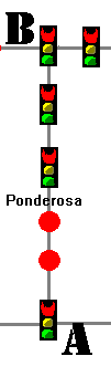 |
Route 1: Straightline from point A to point B.
(Ponderosa Route). The route had a total of 4 stoplights
and 2 stop signs. Distance 1.9 Miles Speed Limit: 40 M.P.H.
|
||||||
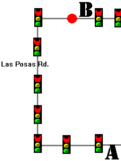 |
Route 2: Line starting left from origin. (Las Posas
Rd Route) This route had a total of 7 stop lights and 1
stop sign. Distance: 3 miles Speed Limit: 45 M.P.H.
|
||||||
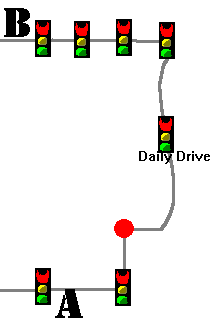 |
Route 3: Routes starts right of origin (Daily Drive
Route). 7 stop lights and 1 stop sign on this route. Distance: 2.6 miles Speed Limit: 30-45 M.P.H.
|
Conclusion: The data has shown that the straight line is still the best route to travel out of the three routes given. However, a fact to be noted is on it's best try, the Los Posas route had beaten the Ponderosa route. This fact makes it possible to claim Los Posas the better route based on average velocity (see bottom Chart). Furthermore on behalf of route three's defense, it may be possible to cut a couple minutes off by avoiding the four stop lights a the end of the trip by taking other routes, however, this is meaningless when driving route three trapped behind somebody doing 25 M.P.H.
Additional Information:
| Route | Average Time | Distance of Route | Stop Lights and Signs | Ave.Velocity | Stops per Mile |
| Route #1 | 5:02 | 1.9 Miles | 6 | 22.4 M.P.H. | 3.2 |
| Route #2 | 5:48 | 3 Miles | 8 | 32.8 M.P.H. | 2.7 |
| Route #3 | 7:37 | 2.6 Miles | 8 | 21.2 M.P.H. | 3.1 |